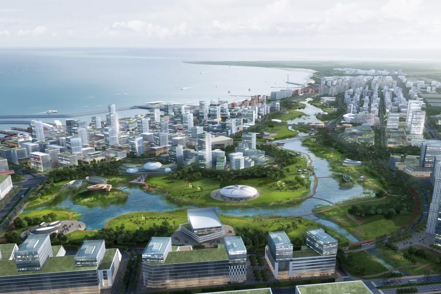
Chapman Taylor’s 956-hectare urban regeneration design for the Dongfang Coast Area in Hainan, China
Chapman Taylor has created an urban regeneration masterplan for the Dongfang coastline of Hainan in China.
The concept envisages a bustling and well-integrated seafront city and port which will encourage residents, businesses and tourists to come to an area of Hainan which has great undeveloped potential, but which is poorly connected and serviced. This urban design fully integrates Dongfang with the wider region and world while providing an inclusive and flexible model for urban growth.
A strategy for phased and flexible urban growth is applied, using a framework of water routes and greenways, a public services network and transportation infrastructure as the basis from which further expansion can occur. The coastal belt forms the trading, tourism and commercial core of the transformed city.
Key to the 956-hectare masterplan is a thriving and sustainable free trade port which will act as the focus for industry and trade in the area. The port is in an excellent strategic location where China’s Belt and Road (sea and land trade routes) meet and will be a key hub for trade with the wider ASEAN region. The wider city will be linked by multiple modes of transport, including ferries, the round-island railway, freight rail, freight hub airports and express highways.
Dongfang will become a pioneering digital innovation city, with the highest standards of digital connectivity serving major companies, entrepreneurial start-ups, R&D and education facilities and those who work remotely. Marine-orientated green industry will be a key pillar of the city’s commerce.
The area’s ecology and landscapes are a major influence on the design, which provides an ecological demonstration area to showcase the area’s biodiversity, particularly its importance to a wide range of migratory birds. The area’s mountains, rivers, lakes, forests, fields and beaches provide the ideal backdrop for a major eco-tourism destination. A Sponge City water management and flood prevention strategy is adopted, using the existing wetlands and drainage system alongside new infrastructure for capturing and storing rainwater.
The goal is to make Dongfang a people-and-nature-friendly city and an economic and tourism powerhouse within an open coastal zone which will act as a gateway to the world.
A strategy for phased and flexible urban growth is applied, using a framework of water routes and greenways, a public services network and transportation infrastructure as the basis from which further expansion can occur. The coastal belt forms the trading, tourism and commercial core of the transformed city.
Key to the 956-hectare masterplan is a thriving and sustainable free trade port which will act as the focus for industry and trade in the area. The port is in an excellent strategic location where China’s Belt and Road (sea and land trade routes) meet and will be a key hub for trade with the wider ASEAN region. The wider city will be linked by multiple modes of transport, including ferries, the round-island railway, freight rail, freight hub airports and express highways.
Dongfang will become a pioneering digital innovation city, with the highest standards of digital connectivity serving major companies, entrepreneurial start-ups, R&D and education facilities and those who work remotely. Marine-orientated green industry will be a key pillar of the city’s commerce.
The area’s ecology and landscapes are a major influence on the design, which provides an ecological demonstration area to showcase the area’s biodiversity, particularly its importance to a wide range of migratory birds. The area’s mountains, rivers, lakes, forests, fields and beaches provide the ideal backdrop for a major eco-tourism destination. A Sponge City water management and flood prevention strategy is adopted, using the existing wetlands and drainage system alongside new infrastructure for capturing and storing rainwater.


